When Abe and I first arrived in Welly (and after sleeping off the 3 days in transit it took to get there), one of
the first things we heard was that we had to visit the Te Papa museum of New Zealand.
While we were there, one exhibit struck me as especially educational and frightening. It was an exhibit about the construct of the earth’s core to help kids understand the earth as a layered and changing planet. As we entered the exhibit it described our planet in words such as “tumultuous heat of the earth’s core always churning beneath our feet…the earth is twisting, tearing, and ripping below us.”
What it told us about New Zealand were things I already knew, but they were a lot more frightening to me that day than they had ever seemed before: New Zealand lies atop a fault line in between two tectonic plates: the Pacific Plate and the Indo-Australian Plate. Mountains, volcanoes, floods, earthquakes, rainstorms, and other natural wonders and disasters occur here because of New Zealand’s placement on this fault line.
Growing up in a suburb of Philadelphia, Pennsylvania, I never learned much detail about the creation of mountains or earthquakes and hurricanes or maybe I just didn’t pay much attention. It seems like it must be different for kids growing up here.
The museum exhibit showcased a huge light-up floor map with topography and the tectonic plate lines drawn in. The exhibit also featured an “earthquake house” which allowed people to feel what it’s like to experience an earthquake and listen to the radio broadcast during an earthquake in New Zealand’s history. Listening to the radio sounds of people panicking, I felt pretty scared, but the kids in the museum just laughed.
After the earthquake house, I must admit that I thought “Why the hell did I want to come to New Zealand?! To die? Not really….” I had read that New Zealand is often called the adrenaline capital of the world, but I didn’t quite realize how literally they actually lived “on the edge.”
I looked up New Zealand on Wikipedia to find out more about the fault line, and I can't say it better:
“New Zealand is part of Zealandia, a microcontinent nearly half the size of Australia that gradually submerged after breaking away from the Gondwanan supercontinent. About 25 million years ago, a shift in plate tectonic movements began to contort and crumple the region….
“The country owes its varied topography, and perhaps even its emergence above the waves, to the dynamic boundary it straddles between the Pacific and Indo-Australian Plates.”
So, even though earthquakes are terrify me, I know now that the plates also bring us the beauty that I celebrated in my last post. I have only seen about one eighth of the country so far, but already I have dozens if not hundreds of examples of the magnificence of New Zealand’s “varied topography” or “contorts and crumples.”
The earthquake in Christchurch was a terrible disaster, and New Zealand has not seen an earthquake of that magnitude for many years. It freaks me out a little bit that only a few weeks after I had decided to name this blog Living on a Fault Line because I felt like I was “living on the edge” a little bit by deciding to quit my job in the United States to come to New Zealand. I didn't really expect it to be literal. But natural disasters are anything but unexpected in New Zealand, especially on the more tumultuous South Island where we are.
As the relief effort in Christchurch continues, all I can do is feel extremely lucky that no one I knew was there and wish all of the people in Christchurch a quick recovery. Right now, they are discouraging visitors from going to Christchurch, but maybe in a few weeks they will be asking for volunteers. I finally have free time stretching out in front of me—no job commitments or rent payments to worry about!—and I would love to help the citizens of Christchurch repair the damage that was done by a natural disaster I can only imagine.
My favorite examples of the surreal topography in NZ so far:
The Franz Josef Glacier (my home right now!)
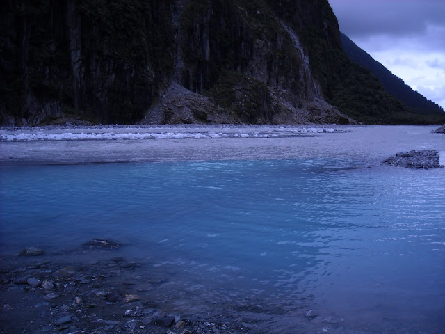
The glacier melts into the valley creating this beautiful river.
Waterfalls are scattered throughout the Southern Alps; this one is in Franz Josef.
The Franz Josef rainforest or "bush" as seen on my daily walk to work.
Lake Mapourika (about 5km or so outside of FJ) at sunset about 9:15pm. Don't be jealous.
Islands just outside of Wellington as seen from the Interislander Ferry to the South Island. You pass countless islands on this ferry ride, and they all look wildly different. It was on this ride that I decided King Kong MUST have been filmed at one of these. Peter Jackson did film it somewhere in NZ!
Fox Glacier (just a 30 min drive south of where I am staying at Franz Josef Glacier)
The river from the Fox Glacier ice melt is so gorgeous. I think the bright blue color of the water must be from the bright blue ice when it melts.
The West Coast, South Island Pancake Rocks by Punakaiki
Another view on the drive from Westport, South Island down to Hokitika, South Island. This West Coast drive is amazing.


these pictures are literally surreal. I can't imagine actually seeing this, but so glad you are
ReplyDeleteum the sunset at 9:15 pm, omg!
ReplyDeletehi thanks a lot for this report. I want to ask what do you feel now. It was good decision to quit your job from USA and come to the newzealand and start work here? Do you want to go back or still want to continue in newzealand. answer me on garima.rga@gmail.com as I am planning to move to newzealand. so just becoz of earthquakes only I am frightening up.
ReplyDeleteThanks for your attention.
Looking forward to you.